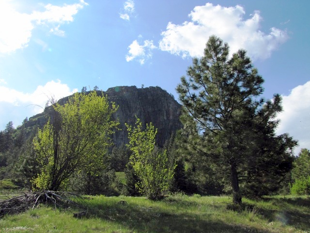
The base of Chief Cliff in Elmo, Montana
There is one major highway that runs north and south through Kalispell. It is Highway 93 and many of our adventures begin there. Heading south it winds through rolling countryside with fine views of the Rocky Mountains and Flathead Lake.
Many times while gazing out the window on drives past the towns of Dayton and Elmo, I have wondered what lurked behind the hills.
Then I read an article about a way to find out. Three years passed before I convinced David that we should explore the area around Chief Cliff. Certainly E’s recent track injury had something to do with his acquiescing. Looking for an outing that would not aggravate her twisted knee, we decided to see what lurked behind the hills.
Chief Cliff Mountain in Elmo is quite recognizable from Hwy. 93. The area is spiritual to the Flathead Indians and as the story goes, a heart – broken Indian maiden threw herself off of the mountain in despair.
In addition to the tale of the mysteriously distraught maiden, the article promised the curious traveler a voyage back in time some 200 years ago. One might experience the area, it was said, as the intrepid David Thompson, the earliest white man to explore the region. Thompson was an excellent map maker and was given the name Koo-Koo-Sint by the Salish which means “he who looks at the stars.” Thompson’s astrological observations and precise map making skills made a considerable contribution to the exploration and development of the North American West. His 1797 observations of Mandan villages in what is now North Dakota were incorporated into a map used by Meriwether Lewis when he wintered in that area in 1804.
Just north of Elmo, we turned onto the gravel road near the water tank as directed. We found ourselves on a cattle ranch overlooking the highway. The road eventually led us to a dead end. Turning around, we followed an old pick up truck going in the opposite direction hoping the driver might have a clue as to how to get to Chief Cliff. He was on a snake hunting expedition and didn’t know .
Traveling back down the gravel road we stopped to take video of the cows. They appeared agitated and mooed loudly. David quipped that they were getting angry and might attack the truck. I compared it to the movie Cujo. Instead of being trapped in a vehicle at the mercy of a rabid dog, we would be threatened by mad cows.
Back on Highway 93, we took another dirt road that led us to a slate quarry. The views were nice but we were no closer to Chief Cliff.
Finally after a wild goose chase, we turned onto a dusty dirt road that the article had described as the way to exit the trip from Chief Cliff. The road gradually narrowed and is the kind that drivers get anxious about -wondering where to pull over if approaching another vehicle.
Slowly but surely we drove farther along the road until Highway 93 disappeared from view. Nestled in the woods was a log home overlooking Black Lake. Driving deeper into the area, we came to Chief Cliff. We took some pictures and turned around to return the way we had come. The road was extremely bumpy and we held on to the “old lady handles” in the truck for support. Past the cemetery and back to the highway and our little excursion was over.
The base of Chief Cliff was nothing spectacular but it did satisfy my curiosity as to what is on the other side of the hills.
Connect with us on Facebook to see all of the pictures from Looking for Chief Cliff.
Happy Trails,
Marlene


One thought on “Looking for Chief Cliff”